To answer a question about land, I begin with an inventory. The Food and Agriculture Organization of the United Nations (FAO) (Food and Agriculture Organization of the United Nations, 1992,[FotUN] 3) tabulated the uses of the world's 13 billion ha of land in 1990. Displayed in Figure 4.1.1, the amount used for arable and permanent crops seems small, that for permanent pasture and forests reassuringly large, and that for other mysteriously large.
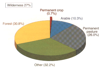 Figure 4.4.1. The uses of the world's 13 billion ha of land in 1990.
Other includes unused but potentially productive
land, built-on areas, wasteland, parks, ornamental
gardens, roads, lanes, barren land, minor water
bodies, and any other land not specifically listed
otherwise (United Nations, 1992, 898). The World
Resources Institute (WRl) (1992) added the category
wllderness, which overlaps other categories. The
WRl defined wilderness as land showing no
evidence of development, such as settlements or
roads. The seeming precision of the areas, of course,
belies the vagaries of definition and inevitable
uncertainties in the FAO's planetary compilations.
For a critique of data about land use, see Meyer and
Turner (1992).[UN:92][Ins92][MT92]
Figure 4.4.1. The uses of the world's 13 billion ha of land in 1990.
Other includes unused but potentially productive
land, built-on areas, wasteland, parks, ornamental
gardens, roads, lanes, barren land, minor water
bodies, and any other land not specifically listed
otherwise (United Nations, 1992, 898). The World
Resources Institute (WRl) (1992) added the category
wllderness, which overlaps other categories. The
WRl defined wilderness as land showing no
evidence of development, such as settlements or
roads. The seeming precision of the areas, of course,
belies the vagaries of definition and inevitable
uncertainties in the FAO's planetary compilations.
For a critique of data about land use, see Meyer and
Turner (1992).[UN:92][Ins92][MT92]
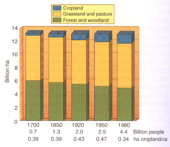 Figure 4.1.2. From 1700 to 1980, changes in the use of the world's
13 billion ha of land, its population, and cropland!
capita. The general changes in land use undoubtedly
are correct although the definitions of land use in
this and the preceding figure are not precisely the
same. The areas of land use are from Richards
(1990). The populations are copied and interpolated
from Demeny (1990, 42).[Ric90][Dem90]
Figure 4.1.2 represents the three centuries of
change that ushered in the state of Figure 4.1.1. The
history of Figure 4.1.2 forces all 13 billion ha of land
into three classes and omits the other class; the inconsistencies
between Figure 4.1.1 and Figure 4.1.2
reveal the ambiguities of such classifications. Nevertheless,
during three centuries cropland surely advanced and forest and
woodland retreated. And the
recent decline of cropland/capita tabulated below the
figure is consistent with the rising yields/hectare that
later figures show.
Figure 4.1.2. From 1700 to 1980, changes in the use of the world's
13 billion ha of land, its population, and cropland!
capita. The general changes in land use undoubtedly
are correct although the definitions of land use in
this and the preceding figure are not precisely the
same. The areas of land use are from Richards
(1990). The populations are copied and interpolated
from Demeny (1990, 42).[Ric90][Dem90]
Figure 4.1.2 represents the three centuries of
change that ushered in the state of Figure 4.1.1. The
history of Figure 4.1.2 forces all 13 billion ha of land
into three classes and omits the other class; the inconsistencies
between Figure 4.1.1 and Figure 4.1.2
reveal the ambiguities of such classifications. Nevertheless,
during three centuries cropland surely advanced and forest and
woodland retreated. And the
recent decline of cropland/capita tabulated below the
figure is consistent with the rising yields/hectare that
later figures show.
Because of rising yields, farmers in some countries today grow surpluses, driving down prices. To combat the bankruptcy of farmers, governments support prices. Some support comes in the form of incentives for farmers to idle cropland. Figure 4.1.3 illustrates the consequent change in land use with a U.S. example. In 1992, government programs idled about one-fifth of U.S. cropland, undoubtedly much of it marginal and illustrating how land can be spared when yields rise on other land.
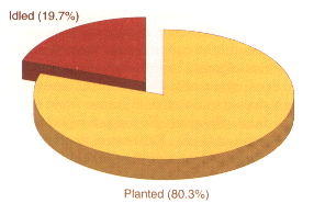 Figure 4.1.3. The fraction of U.S. cropland idled by government
programs in 1992. The Food and Agricultural Policy
Research Institute (FAPRI) tabulated the area
planted to 15 principle crops in the United States
and the area idled by two programs identified by the
acronyms ARP/PLD/O-92 and CRP. The idled areas
have been or are projected to be about steady 1989-1997,
but FAPRI projects them to decline after 1997
(Food and Agricultural Policy Research Institute,
1992, 83).[FF92]
Figure 4.1.3. The fraction of U.S. cropland idled by government
programs in 1992. The Food and Agricultural Policy
Research Institute (FAPRI) tabulated the area
planted to 15 principle crops in the United States
and the area idled by two programs identified by the
acronyms ARP/PLD/O-92 and CRP. The idled areas
have been or are projected to be about steady 1989-1997,
but FAPRI projects them to decline after 1997
(Food and Agricultural Policy Research Institute,
1992, 83).[FF92]
So crops have expanded over about a tenth of all land, but rising yields/ha have allowed the expansion to be somewhat slower than the multiplication of population, and some cropland is held out of production.